This is my first blog post about remarkable flight sim routes that I’ve flown in the simulator. I’m an avid flight simulator fan for more than 8 years now. Beeing tired to fly the same routes over and over again without learning as much as in the beginning of my engagement with this hobby, I decided to turn to some more complicated topics in the last years. This first post is an insight into what I could find out about the topics presented in this post. I am not a pilot and happy for any comment or suggestion you may be able to give.
Why is this flight interesting?
There are three main reasons for me. First, the route — this journey takes you from the deserts of the Middle East, scraping the North Pole back down to warm and sunny California. The second reason I picked this one is the scenery. You can start out with FlyTampa’s marvelous Dubai scenery and land either in SFO or LAX, which both have a very nice reincarnation from FlightBeam Studios respectively FS Dreamteam. Last but not least, this is not only an ultralong
flight, but also an adventure concerning climate and aircraft capabilities, or where else would you need to think about fuel temperatures?


What do I need?
Basically, you just need a plane and FSX. I would also encourage you to study Belisar Hoxholli’s ETOPS and Oceanic Procedures Guide.
- Professional Flight Planner X (PFPX)
- FlyTampa’s Dubai Rebooted
- FsDreamteam’s Los Angeles or FlightBeam’s San Francisco
- PMDG’s 777
- a few charts
Planning the route
Planning is somewhat the real part of what I enjoy about flight simulation. After some years of experience I can say, the better the planning, the better the flight. Most of you will be well familiar with european and US airspace routes. For european routes you always have the option to validate you route with Eurocontrol’s validator. US based routes are even easier to grab on flightaware. Before going further into the route planning, one litte recommendation from my side: use flightaware! It will give you at least parts of a real route which you can use, so there will be less you will need to worry about when planning this marathon trip. Unfortunately it’s not possible to get the full route from Dubai at flightaware. The following will show you how to plan your flight with a realistic route.
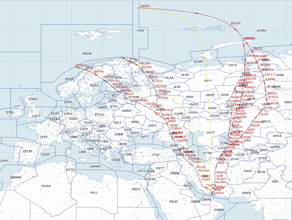
So let’s start looking at the route options we have. You’ll learn that we are slightly limited on one side of the globe, whereas we have pretty much options on the other. The following image shows the first part of Emirates’ route options from the Middle East up to the pole.
These are the routes used by Emirates to get over the Artic Ocean. Both main directions will make you overfly Iran, some former USSR republics and then crossing smaller or bigger parts of Russian airspace. The eastern route uses the Polar 1 exit/entry fix ABERI close to the North Pole (note: the Polar 1 route is not used as it connects the North Polar Region with China), while the western route goes straight over Bear Island which is a part of the Svalbard archipelago. The basic decision wether to use the western or eastern corridor is done by looking at the weather.
Aloft winds are — as usual — a key factor when choosing the initial direction of the flight. Typical wind and weather patterns prove the Polar routes to be most efficient tracks the majority of the time. However, there may be occasions when a non-polar routing is faster, more efficient, or simply required due to weather, traffic, solar activity, or other considerations.
The first part of the route makes you go through Iranian airspace which in summer can be very challenging. One of the reasons is the Intertropical Convergence Zone (ITCZ) bringing large thunderstorms to the area. Watch out for CBs, have an eye on SIGWX charts and use your WX radar.
Following the route you will either cross the Caucasus Mountains or large parts of Central Asia for your entry into the airpace of the Russian Federation. While the Russian Federation implemented RVSM and flight levels in feet in the upper airspace in 2011, there are still some important differences to European and North American airspace. The Main Air Traffic Management Centre of Russia is posting routes for Russian and non-Russian airlines that need to be followed when overflying Russian territory. This leaves three fixed routes for the eastern corridor, and three for the western one.
The routes for the estern corridor are:
- DARAX N440 BOSOS UN440 MOBON W10 SYZ UP574 SAV R654 ZAJ UR654 MAGRI N77 ADANO N82 LAPTO A234 USEMA R11 PT B119 FE FE3T BESTA DCT KN FK2T NE G476 PELOR A74 VANOS P65 SDA DCT MAGIR
- DARAX A419 TAVNO L430 SRJ W32 ANK UL125 RADAL N39 NSR R794 ULDUS N39 MEKAN R120 ST A928 FE FE6T AO FE5T LAPUR FE6T KN FE1T NE G476 PELOR A74 VANOS P65 SDA DCT MAGIR
- DARAX UN440 BOSOS UN440 MOBON W10 SYZ UP574 SAV R654 ZAJ UR654 MAGRI N77 ADANO N82 LAPTO A234 MARAT R806 MNW R11 BUTRI R120 KOROT R364 TE B231 UK R11 TU R58 NOTAR P854 NORVA
And for the western corridor:
- DARAX A419 RIKOP B114 ASB B434 MAXAT A370 MIMRI B944 DAKIN R706 ANODI G359 ABERI
- DARAX A419 RIKOP B114 ASB G775 AFGAN A370 URG A299 TINRI G359 ABERI
- DARAX A419 RIKOP B114 ASB G775 AFGAN A370 URG A299 AKALI B825 LANOR R482 LBN R486 EKB G552 GIMAK G497 BEBIR G498 SH G359 ABERI
Let’s go polar …
For the sake of this blog entry, we’ll now concentrate on the eastern corridor. So what exactly is polar operations? According to the FAA polar operations means any operation above 78 deg north latitude. This is not to be confused with the FMC’s internal logic and definition of polar operations being above 82N and the “keyhole” of W080 to W130 down to N70.

Furthermore, the Boeing 777 FCOM states:
FMC Polar Operations
When entering the polar region, automatic switching to a true north reference is annunciated by a white box around the word TRU on the ND. A TRUE heading reference can be selected with the heading reference switch inside or outside the polar region. The ND displays a green box around the word MAG to annunciate the change back to magnetic reference when leaving the polar region. If the heading reference is TRU in the descent phase, the ND displays a flashing amber box around the word TRU.
The current GRID heading displays near the top of both NDs when the airplane is north of 70°N or south of 70°S. The GRID heading is not used by any airplane system.
In the real world we have several aspects to focus on when it comes to operate in the arctic area:
- Regulatory guidance,
- Enroute alternate airports,
- Cold fuel management,
- Communication and navigation.
We’ll concentrate on enroute alternate airports and cold fuel management, starting with fuel management.
Cold fuel management

After crossing the Artic circle, it will get very cold. During winter it is not unsual to see the temperature drop as low as –70°C at FL350. The freeze point of a fuel is the point at which the last wax crystal melts in a frozen sample. This value is approximately two degrees warmer that the point at which the first wax crystal forms as the fuel is cooled. For Jet A, the specification freeze point is –40°C (Jet A-1 –47°C). A 3°C operational margin is provided, yielding an operational limit of –37°C (Jet A-1 –44°C). The first wax crystal would form at –42°C, so a margin of five degrees is provided. When operating in an area of SATs of –65°C or less a sound planning is neccesary to avoid a minimum fuel temperature warning in your aircraft. As a rule you can rely on a rate of cooling of fuel at approximately 3°C/h. A maximum of 12°C/h is possible under the most extreme cold conditions [1]. Pay attention to the altitudes of the Tropopause and associated OATs. Typically the Tropopause may be as low as 18,000-24,000 feet over Polar routes.
From an airline’s Polar Operations Manual:
When operating in an area of SATs of -65 C or less, crews need to remain vigilant to ensure the minimum fuel operational limit is not exceeded. If the limit is approached, consider changing altitude, or changing routing. It generally is better to manage fuel temperature with altitude/SAT than Mach/TAT. Increasing Mach will raise TAT, but burn considerable fuel. Increasing your Mach from .84M to .85M will yield approximately a.7 to 1.0 increase in TAT. Careful altitude planning will save fuel. Routing changes can be difficult in Russian airspace. Changing altitude is generally a better solution. Consider that extremely cold air tends to pool in the Tropopause and that warmer air can sometimes be found at altitudes above the Tropopause.
Polar diversion airports
Flights in the polar region normally operate under the ETOPS 180 minutes rule. The leaves at least some alternates which we’ll have a look at. Some of them will be used for the western and some for the eastern corridor. Airports marked as “last resort” are not to be considered as planned alternates.
ENBO — Bodø Airport — Norway
ENTC — Tromsø Airport, Langnes — Norway
ENSB — Svalbard Airport, Longyear — Norway
ULMM — Murmansk Airport — Russia
UEST — Tiksi Airport — Russia (last resort)
ULAA — Talagi Airport, Arkhangelsk — Russia
UOOO — Alykel Airport, Norilsk — Russia
BGTL — Thule Air Base/Pituffik Airport — Greenland (last resort)
BGSF — Kangerlussuaq Airport — Greenland
CYFB — Iqaluit Airport — Canada
CYRB — Resolute Bay Airport — Canada (last resort)
CYYQ — Churchill Airport — Canada
CYLT — Alert Airport — Canada (last resort)
CYEU — Eureka Aerodrome — Canada (last resort)
CYBK — Baker Lake Airport — Canada (last resort)
CYZF — Yellowknife Airport — Canada
Through the Western Hemisphere
After passing the Polar 1 exit fix ABERI on the Russian side we follow a random route close to the North Pole, then entering Edmonton FIR until passing the border to the United States. Whereas our route through the Eastern Hemisphere was very restricted by Russian ATC facilities, we have many options for our route down to California. As a rule of thumb our flight plan should include waypoints seperated by 5° latitude starting and 85° N, not going beyond 123° W longitude. The following maps show route segments for SFO and LAX extracted from flightaware in the first quarter of 2014.


Here are some route segments for KLAX:
- FOLDY071060 EPH IMB FMG J7 REYES V107 PIRUE FIM SADDE6
- FOLDY071060 EPH IMB FMG J7 REYES V107 SADDE SADDE6
- FOLDY071060 EPH IMB FMG REBRG Q9 DERBB SADDE6
- FOLDY071060 EPH IMB FMG J7 FIM SADDE6
- FOLDY071060 EPH IMB FMG REBRG DERBB FIM SADDE6
- FOLDY140008 KS12G KS72G FMG EHF V23 GMN V299 FIM SADDE6
- FOLDY140008 KS12G KS72G FMG REBRG J7 DERBB J1 FIM SADDE6
- FOLDY140008 KS12G KS72G FMG EHF V23 GMN V299 FIM V107 SADDE SADDE6
- YVR J126 OLM BTG J189 AVE J1 DERBB MOOR3
- YVR J126 OLM BTG GMN V299 FIM SADDE6
- 4905N 11616W REO LLC FRA EHF V23 GMN V299 FIM V326 GINNA V107 SADDE SADDE6
- 4905N 11616W REO LLC FRA EHF V23 GMN V299 FIM SADDE6
- 6000N 12200W 5500N 12200W 5000N 12100W KS12G KS72G FMG REBRG J7 DERBB J1 FIM SADDE6
And some options for KSFO:
- YDC LMT J65 RBL GOLDN6
- YQU YDC LMT J65 RBL GOLDN6
- YQU YDC LKV J67 LIN V113 ECA RISTI4
- YZU KS21I IMB LKV RBL GOLDN6
- 5000N 11600W KS12I RBL GOLDN6
- 5000N 11800W KS06G RBL GOLDN6
- 5500N 12400W YVR J126 OLM J126 EUG J143 RBG GOLDN6
- 5500N 12300W YVR J126 OLM BTG J1 OED J501 PYE GOLDN6
- 5500N 12200W 5000N 12200W KS12E KS72E RBL GOLDN6
- 6000N 12400W 5500N 12400W YVR J5 SEA J65 RBL GOLDN6
- HRMNS J189 LMT J65 RBL GOLDN6
- BOI FMG GOLDN6
- ABERI 8500N 11300W 8000N 12100W 7500N 12300W 7000N 12200W 6500N 12200W 6000N 12200W 5500N 12200W 5000N 12200W KS12E KS72E RBL GOLDN6
- SEA J65 RBL GOLDN6
- FRFLY Q3 PYE GOLDN6
- BRYGE J541 YYJ FEPOT Q3 PYE GOLDN6
This route segment will very much rely on alternate availability and wind and weather patterns. Check the NOTAMs for your planned route. Airports on your way might be below ETOPS minimas or closed for maintenance.
The other option
Occasionally the western corridor in the Eastern Hemisphere is used, turning your flight into a completely different experience. In this case you’ll still be very much up north, but more like on a trip from Central Europe to the West Coast overflying Greenland.
Greenland has very high MORAs, often surpassing 10,000 ft which makes use of decompression escape route charts for this territory necessary. I’ve attached my own chart trying to replicate the charts used by Air Canada. It might be useful for other polar flights as well.

Departing Dubai …
… can be a struggle sometimes as there are very hot ambient temperatures exceeding 40°C (104°F) in summer. Refer to FCOM 1 SP.2.3 for APU to Pack Takeoff procedure, which might give you the advantage. Normally MTOW will not be limited, but Emirates’ has established a special procedure for payload protection. Basically they set up two flight plans:
- One direct OFP to the intended final destination based on requested ZFW for passengers and baggage based on the Decision Point Procedure (DPP a.k.a. Redispatch)
- One OFP for an intermediate technical stop along the route to refuel, based on requested ZFW
When the flight closes 60 minutes before ETD, a decision will be made to operate direct or with a technical stop, based on actual load and latest available ambient condition predictions for the ETD plus 60 minutes.
If required for performance reasons, and operational (outside the Runway-Closure period), it is determined whether RWY 30L can be used for departure. Runway 30L will only be made available when a departure from runway 30R would result in a payload reduction and may cause additional delays.
Arriving in LAX or SFO
Welcome to two of the world’s most congested airspaces.
LAX arrival
From BAV Virtual Route Information Manual:
SOCAL Tracon in San Diego set up all approaches and hand them to LAX Tower at JETSA or LIMMA intersections. Their initial presumption is that jets will use the outer runways for landing and turbo props the inners. Therefore, rwys 24L and 25R can normally be expected for arrivals and 25R for departure. Approaching from the North East (Hector or Peach Springs), expect to be cleared for the RIIVR arrival, which can lead to any westerly runway.
Expect clearance from first contact with Socal Tracon:
“Descend via the RIIVR x Arrival, then cleared for the ILS 24R” (or as appropriate).Note that a “Descend via the…” clearance implies a vertical and lateral clearance, whereas a “Cleared for the RIIVR…” etc only implies a lateral clearance, and descent must be negotiated separately.
A clearance onto the ILS still requires crews to meet the minimum (and in some cases, maximum) altitudes as per the ILS chart (to avoid VFR traffic in the light aircraft corridors below the approach) and the charts show a glide path intercept altitude on all runways. In practice it is acceptable to arm the glideslope after passing the last altitude constraint before the FAF. These approaches are “slippery” and may require earlier than normal use of drag to lose altitude and speed together.
When an arrival publishes a range of altitudes for a point, programming in the lower can and will reduce later drag problems. Expect the final release to be “maintain 180kt to JETSA/LIMMA” which is 8 NM from the TDZ.
Aircraft arriving from the North (SADDE) can normally expect the Northern runways.
In addition to the published speed/altitude a restriction, experience has shown that 7000ft/210kt at SMO is a useful gate (NB 6000ft light aircraft at SMO). Clearance at this point is normally “Hdg 070, descend 2500ft”.
It is a good idea to get down to this altitude promptly as on the base leg there will be opposite direction traffic at 3500ft positioning for the Southern runways, but note that the base of Class B airspace in this area is 2500ft, so there could be VFR traffic only just below.Crew often find themselves overtaken on landing by small aircraft flying to the close parallel runway who are landing deep. They have instructions to pull up to but not pass the larger aircraft while still in flight, but can look very close. TARA should remain selected on TCAS. There will always be good vertical separation between aircraft on the North and South complexes as the Rwy 25 thresholds are deeply inset.
Approaches for the easterly runways are rare at BAV arrival times, but the REEDR or BASET and DOWNE or REDEYE arrivals lead to the Southern and Northern complexes respectively.Runway changes are common and are usually intended to avoid go arounds because of reduced separation with preceding aircraft. Because of the close proximity of traffic on other approaches and at neighbouring airports it is not possible to introduce vectors for spacing and so ATC can only give speed changes or runway
Changes, the importance of everybody complying immediately with ATC speed requests is obvious. Speeds on the approach are generally quite high; this is intentional and is intended to increase the arrivals rate during busy periods.Missed approaches from the 2 complexes diverge for separation.
State the assigned parking stand number on first contact with TWR or by the marker, this enables better coordination of taxi routings. After landing, contact GND immediately upon being instructed, even if it is still necessary to cross a runway. If this is the case, ATC will ensure that it is kept sterile. Crews may also be asked to hold short of the other runway.
LAX now has a Runway Status Light System (RWSL) which should be described on the airfield charts.
The key messages are that the lights indicate status not clearance, and red means stop (or go-around as appropriate).
SFO arrival


From BAV Virtual Route Information Manual:
NORCAL Tracon (NCT) set up the initial approach and allocates right-hand or left-hand arrivals based on the best fit with arriving traffic. Crews wishing to fly the right-hand pattern should request this from NCT. Although the arrival direction will normally lead to the corresponding 28 rwy, TWR can vary this in the later stages to optimise rwy occupancy. Once on the final approach, sidestep manoeuvres are not offered to foreign carriers but may be requested if operationally advantageous.
When arriving from the North, normally via the Golden Gate STAR, approaches to 28R are typically from overhead at around 11000ft. If cleared for a right-hand pattern, expect vectors onto an initial heading of approx 100° to a visual approach (Quiet Bridge, usually for 28R, although it can also lead to 28L) usually resulting in a short distance in which to lose considerable height (known locally as the „Slam Dunk.).
These arrivals are usually more fuel efficient than a left-hand pattern but need careful attention to the flap and gear configuration to achieve stabilised approach criteria. Requests to extend the right-hand downwind leg are difficult for ATC to approve because of conflictions with Oakland rwy 29 approaches and San Jose rwy 30 departures, and also with SFO arrivals from the East.Expect to be cleared to 4000ft and 3000ft quickly and then be given an early turn back towards rwy 28R resulting in establishing on the Localiser above the glideslope. Do not allow capture of the 3000ft altitude before becoming fully established on the ILS.
Left-hand arrival patterns are more leisurely with vectors initially to around 140° either onto the ILS 28L or a visual approach (Tip Toe 28L). When cleared on a visual approach maintain the correct inbound VOR track until past the specified point, i.e. do not establish early on the centreline.
Although these visual approaches do not have missed approach procedures, they do have published go-arounds. Simultaneous visual approaches are permitted; note that the distance between runway centrelines is 750ft and that the Quiet Bridge 28R initially converges with the 28L centreline. Wingtip-to-wingtip flight is not permitted and crews avoid overtaking the neighbouring aircraft for wake-turbulence reasons.
Crews that do inadvertently overtake and lose visual contact should consider a go-around. In a crosswind there may be turbulence implications from the adjacent approach, especially when the other aircraft is also a “heavy”.Whenever forecast arrival weather is below 5SM vis/2100ft cloudbase, arrival delay fuel should be added to the flight plan (15 mins of Min LDG Fuel = 2300kgs). When the airport is operating in a Westerly configuration (landings and departures on 28L/R and departures on rwy 01R), weather conditions below this will generally not permit visual approaches and so the arrival rate will go down. When the airport is on a Southeasterly configuration (often during stormy weather, and usually landing rwys 19L/R and departing rwys 10L/R, though occasionally arriving and departing 19L/R or more rarely landing and departing on the 10s) arrival and departure delays are possible and so arrival delay fuel will also be added. This is because of vectoring on approach and because Easterly departures are all along the same outbound radial and separation requirements cause delays.
Note that except for the RNAV (GPS) for those aircraft types cleared for it, there are no IFR approaches to rwys 10L/R.
When weather conditions permit, ATC may use Simultaneous Offset Instrument Approaches (SOIA) to the rwys 28. When these are promulgated by ATIS and cleared by ATC, 28L will be a straight-in ILS-PRM approach and 28R will be an LDA-PRM approach (essentially an ILS) offset from the runway centreline by 3°. Heavy aircraft will normally be on 28R, following the 28L aircraft.
On becoming visual it will be necessary to acquire both the other aircraft and the runway, and then to manoeuvre across to the centreline, but only when at the MAP to avoid transgressing the NTZ. Note that there is still also a straight-in ILS to 28R.Note also that it is not possible to “line-select” the ILS-PRM or LDA-PRM in the FMS, although all the waypoints are in the nav database, and thus need to be manually selected (including those on the missed approach), as does the ILS or LDA (110.75/278). Do not construct waypoints. The missed approach point (DARNE) is defined by D4.0 IFNP and the missed approach is flown initially in HDG SEL.
Note also that there is a crosswind limitation of 10kt when SOIA operations are in force. It is permissible to request the 28R LDA for practice even when SOIA is not in force. Locally specific PRM procedures are: while communicating with NCT, tune the PRM Monitor Frequency no later than localiser intercept.
Expect to be switched to Twr frequency for both approaches at, but not later than, NEPIC (28L) or DARNE (28R).
