This time we’re in for another adventure in the sim making our way from London, United Kingdom to Hong Kong Kai Tak Airport. Wait a minute Kai Tak, wasn’t that closed back in 1998? Yes it was, and it’s up to you to use old Kai Tak or the new Chek Lap Kok Airport located on an artificial island.
I recommend flight number CPA254 operated by Cathay Pacific. The flight departs in the dark and arrives around 5 pm local Hong Kong time.
Your equipment
- Professional Flight Planner X (PFPX)
- FlyTampa’s Hong Kong Kai Tak
- UK2000 Heathrow
- PMDG’s 777
- a few charts
Lima Triple Eight — L888
The basic routing of this flight follows Amsterdam, Northern Poland and Belarus over to Moscow further to the south-east crossing vast portions of Kazachstan. After entering Kyrgyzstan, overflying Lake Balkhash, we get to the interesting part of the route. Bordering China and Kyrgyzstan the Tian Shan mountain ranges rise up to more than 24,000 ft. The following 300 nm take us over the Taklamakan Desert at around 4200 ft, before taking on the Tibetan Plateau for more than 900 nm at MSAs around 20,000 ft.
Airway L888 was implemented in late 2000 to cross the western part of China including the Tibetan Plateau. Although the MEAs on this route are amongst highest on earth a couple of airlines wanted to shorten their routes from Europe to Asia. The airway was opened as a FANS (Future Air Navigation System) route. Basically this means that you need to login with CPDLC to communicate with ATC via SATCOM, besides having an ADS-B transponder on board.
When flying above such high terrain you have to consider two things which you might be familiar with from your ETOPS planning: Engine-out and decompression scenarios. Under normal circumstances both scenarios are no big deal, as you will always be able to descend to your engine-out altitude or in case of a decompression down to 10,000 ft. Because of the high terrain this is not possible here, therefore you need to use so called Escape Routes to get over lower terrain and potentially plan your landing at one of the surrounding alternate fields.
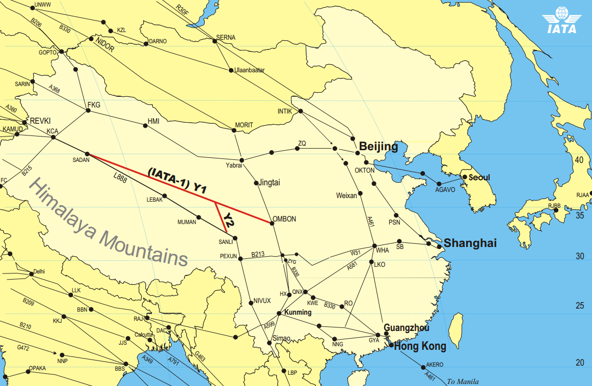
Flying with one engine-out on a 777 after more than 7.5 hours (southbound) or 2.5 (nortbound) normally puts us somewhere around FL300 which wouldn’t be a problem. The real challenge are the decompression scenarios, in particular the passenger oxygen supply. You need extra oxygen when flying on L888 due to the inability to descend to 10,000 ft from some locations along the route. Most airliners have about 20 mins of oxygen for their passengers for a driftdown procedure. This leaves a good margin for the regulatory requirement to be at FL140 when the supply is completely consumed. For L888 you need to extend that to up to 90 mins, and this is what makes using L888 a complex and expensive journey, because your airline needs to equip at least some of its aircraft with special equipment. Subsequently, airway Y1 (IATA-1) was introduced, making flights a little further north possible without imposing any extra oxygen requirements. Nowadays, most airlines use Y1 and other route options instead of L888, some of these alternatives did not even exist when L888 was opened.
The attached Escape Route Chart gives you an overview about MSAs and diversion alternates you should pick for either north- or southbound flights. This chart does not replace proper enroute charts.


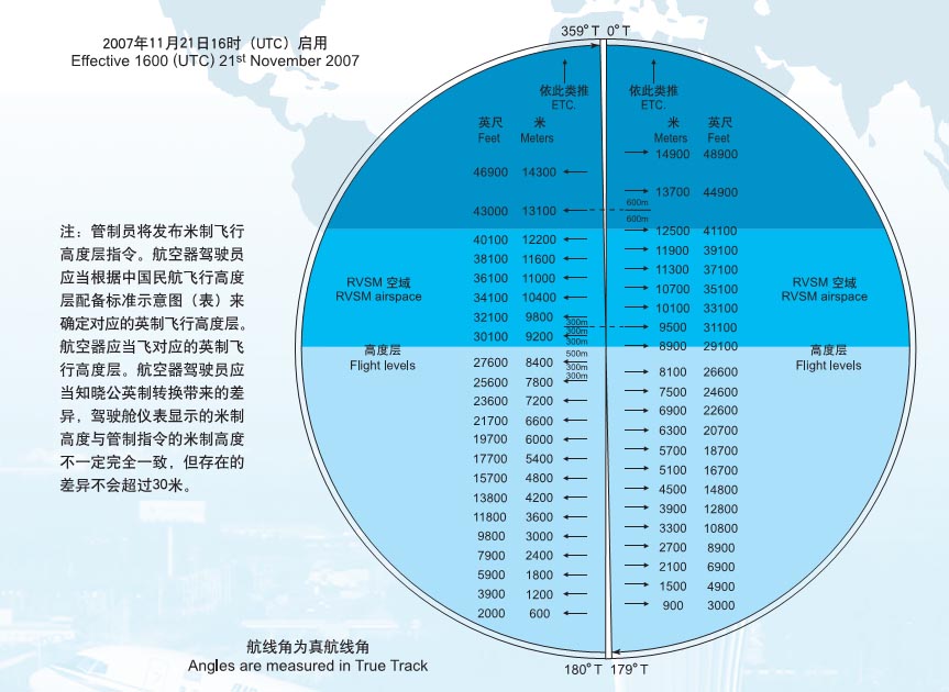
Going metric
As the Russian Federation has switched to FL in feet in the upper airspace some years ago, there are only a few countries on earth now which still stick to the metric system. China is one of them and defines the following FL Transition Procedure for our route:
CROSSING OF KAZAKHSTAN/CHINA FIR BOUNDARY
Aircraft operating flights between Kazakhstan and China should cross the state border at waypoints RULAD and SARIN at flight levels used in China. The change of flight level should be made within Kazakhstan airspace by ATC instructions on following airways:
A124, between BARUR and LAGUK
A360, between GASBU and BERTO
A368, between TOLKI and AGUSA
B142, between GASBU and BERTO
G270, between BASPI and BERTO
G155, between BURID and GILAKor other airway segments as instructed by ATC, but in any case not closer than 30Km to the state border.
China’s RVSM FL Allocation Scheme:
Landing in Kai Tak
Kai Tak IGS 13 approach (charts) sometimes referred to as “the mother of all approaches” is without a doubt one of the most exiting approaches that ever existed. IGS stands for Instrument Guidance System and describes a modified ILS to accommodate a non-straight approach.
Taken from VHHX 11-4
The system uses ILS components but is offset from the landing direction by 47°. Pilots on final approach on the IGS must therefore make a visual RIGHT turn to line up with the runway after reaching decision height. During this visual portion it is imperative that the correct visual cue with the surface is carefully maintained, making reference to aeronautical ground lights where appropriate. In view of the runway, operators intending to use the IGS must ensure, for flight safety reasons, that their pilots are fully conversant with, and have adequate practice in, published procedures.
